
Clear Creek gold panning is allowed at a few public spots along the Colorado creek between Idaho Springs and Golden, and the rules change with each stretch. The main places are the posted areas of Clear Creek Canyon Park, county open space and national forest land near Idaho Springs, and the Arapahoe Bar area just east of Golden.
The creek runs east through Idaho Springs, down the canyon beside US 6 and out through Golden. Private land, city parks and county open space all sit along it, so a spot that looks open may not be. Don’t mix it up with the Clear Creek at Whiskeytown in California, which has its own panning rules.
This 2-minute video covers where you can pan, what gear is OK, when to go and what our claim map shows along the creek.
Where you can pan along Clear Creek
- Clear Creek Canyon Park (Jefferson County): This park west of Golden is the only Jefferson County Open Space park that allows recreational gold prospecting, and only in the creek. The county’s current rules say to follow the posted signs. Its 2024 activity guide puts the stretch between US 6 mile marker 270.5 and the county line near mile marker 260.5, and says you don’t need a park permit. The 2021 park map marks prospecting areas near the Mayhem Gulch (32447 US Highway 6) and Big Easy (32088 US Highway 6) trailheads, and it shows the park land south of the creek there as closed, so let the signs on the ground decide.
- County open space and national forest near Idaho Springs: Clear Creek County says gold panning is allowed on Clear Creek County Open Space land and on US Forest Service land. The county doesn’t list spots, and the Forest Service says some areas, such as developed recreation sites, are closed to mining, so call the Arapaho and Roosevelt National Forests office at 970-295-6600 and ask for the Clear Creek Ranger District before you go.
- Arapahoe Bar (Wheat Ridge): The City of Wheat Ridge allows panning in Clear Creek only at this area, on the north side of the Clear Creek Trail about a quarter mile west of Youngfield Street and I-70. Park at the Youngfield Trailhead lot at 4100 Youngfield St. and walk west on the trail. No panning of any kind is allowed east of Youngfield in the Wheat Ridge Greenbelt.
- Inside Golden: We couldn’t find a published city rule that names panning. Golden’s 2014 Clear Creek Management Plan lists gold panning among the creek’s appropriate uses, but the creek through town has its own rules, so call the City of Golden at 303-384-8000 before you dig there.
- Private land: Clear Creek County says panning on private property takes the owner’s consent.
- Mine tours: Phoenix Gold Mine in Idaho Springs includes panning with a tour ticket. In November 2026 its site said low water had paused creek-side panning on its own, so call 303-567-0422 first.
What gear is allowed
A gold pan is the safe choice on every stretch that allows panning, and anything bigger depends on where you stand:
- Clear Creek Canyon Park: Dredges are allowed with a nozzle of four inches or less. Equipment can’t leak fuel or stay overnight. The rules don’t mention sluices either way, so ask Jefferson County Open Space at 303-271-5925.
- Clear Creek County land: The county’s OK covers “a person with a pan,” with no sluice box and no dredge. Going past that may mean filing a Notice of Intent to Prospect with the state and the Forest Service.
- Arapahoe Bar: Panning and sluicing are allowed in the creek bed. Battery equipment is fine if the battery sits in a battery box, and gas-powered equipment is not allowed.
- Metal detectors: None of the creek rules we read cover them, so ask the office for that stretch.
Colorado’s Division of Reclamation, Mining and Safety said in a 2016 letter that it doesn’t regulate gold panning and hobby prospecting that disturbs less than 1,600 square feet. Local rules can still be tighter, and other agencies may have a say over a dredge. Golden gets most of its water from Clear Creek, so ask the city before you run a sluice or dredge anywhere upstream of town.
In the canyon, Jefferson County wants you in the normal, disturbed stream channel, and it says “keeping one foot in the water is a step in the right direction.” Don’t dig into stable banks or plants, fill every hole before you leave, and stay 100 feet from bridges, steps and fish habitat work. At Arapahoe Bar, don’t dig on the south side of the creek, dig straight down, and keep away from trees and plants.
When to go
Snowmelt makes Clear Creek fast and cold in late spring. Prospectors who work the canyon call May and June dangerous, and late summer is when low water lets you reach more of the creek. In 2025, Jefferson County and the City of Golden limited swimming, tubing and other water activities from Highway 119 through Golden from June 9 to June 24. The creek was running about 675 to 725 cubic feet per second when that started. Those limits weren’t written for panning, but water that closes a creek to swimmers can knock you down too. Check the USGS gauge for Clear Creek at Golden before you drive up. Winter is harder, since ice can block the banks.
How gold came to Clear Creek
Clear Creek County says George A. Jackson found placer gold on January 5, 1859, where Chicago Creek meets Clear Creek in today’s Idaho Springs, and calls it the first substantial gold discovery in Colorado. A USGS report says gold came almost wholly from placers and washed-out vein outcrops from 1859 to 1864. The county produced about 2.4 million ounces of gold through 1959, counting both kinds of mining.
The county’s history says hard rock mining went on long after the gold-bearing gravels were exhausted, so keep your hopes modest. Prospectors in the canyon report that much of the gold is very fine, which takes slow, careful work with the pan. Our guide on how to pan for gold shows the steps, and our gold prospecting equipment guide covers what to bring.
What our maps show around Clear Creek
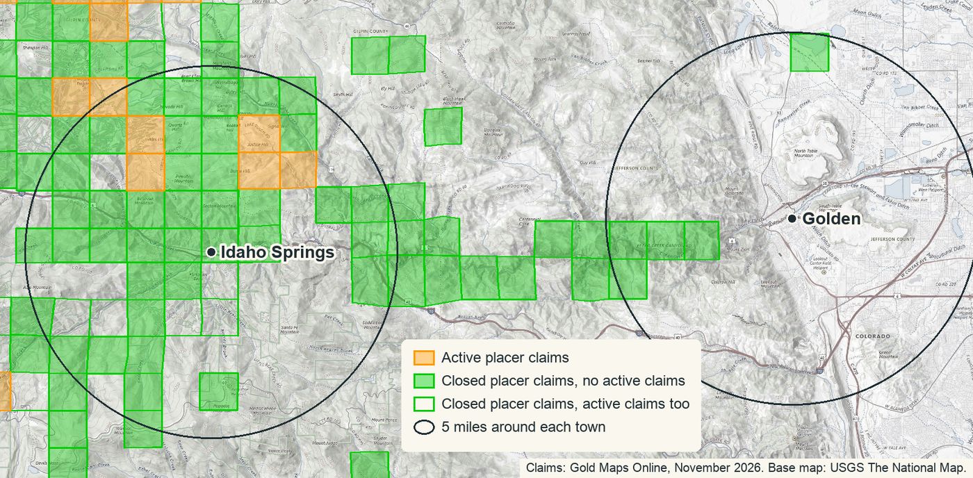
We counted claims within 5 miles of two towns on the creek, using our November 2026 maps. A section counts if its center is inside the circle, and a claim that crosses a section line counts in each section it touches, so treat these as close, not exact.
| Within 5 miles of | Idaho Springs | Golden |
|---|---|---|
| Active placer claims | About 10 | 0 |
| Active lode claims | About 12 | 0 |
| Closed placer claims | About 487 | About 5 |
| Closed lode claims | About 1,295 | 0 |
| Old mines and prospects | About 2,562 | About 91 |
Very few active claims are left near either town, and the active placer sections around Idaho Springs sit north of town, away from the main creek. Use the layers in this order:
- Active placer layer: These sections have current claims, so stay off that ground unless you have the claim owner’s permission.
- Closed placer layer: Closed claims show ground someone once thought was worth staking.
- Old mines layer: This one shows where the old timers dug.
- BLM’s records: Copy the code from the box on our map and check that spot in BLM’s records before you dig, because claims change every week.
The maps show where to look, not permission to dig. A low claim count doesn’t make a spot open either, because our claim layers don’t show private land, old patented claims that are now private, or city and county rules.
Before you dig
The EPA lists 400 square miles of this watershed, from the Continental Divide to near Golden, as the Central City/Clear Creek Superfund site because of heavy metals from old mining. The listed risks include swallowing tailings and waste rock, so stay off waste piles, wash your hands before you eat, and stay out of old mine openings.
Rules on this creek change from one stretch to the next, so confirm them with the office for your spot: Jefferson County Open Space, the Clear Creek Ranger District, the City of Wheat Ridge or the City of Golden. For more places to try, our placer gold locations guide goes state by state.
Our Colorado gold map puts all five layers on one map for the whole state, so you can check Clear Creek and every other district before you go. It works in Google Earth on the web, the Google Earth phone app and Organic Maps.