Oregon Gold Maps
Updated November 2026
Is there gold in Oregon? Yes. Our Oregon Gold Maps show there are currently 10,104 active gold claims and 116,152 abandoned gold claims located throughout the state. Of those active claims, 6,489 are lode claims and 3,615 are placer claims. Of those abandoned claims, 80,647 are lode and 35,505 are placer. Oregon’s roughly 10,104 active gold claims represent about 1.9% of all active gold claims in the lower 48 states.
10,104
active gold claims
116,152
abandoned claims
6,971
old mines and prospects NEW
What you’ll see in the Oregon gold map
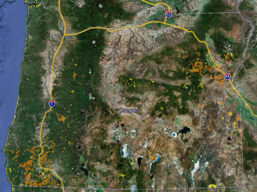
Start with the whole state
When you first open the Oregon gold map you will get a satellite view of the state boundaries with little yellow/orange clusters throughout. Those yellow (lode claims) and orange (placer claims) clusters represent high concentrations of active gold mining claims. This view of these clusters gives us a very accurate idea of where most of Oregon’s gold is being found. Abandoned claims will appear as little blue (lode) and green (placer) clusters.
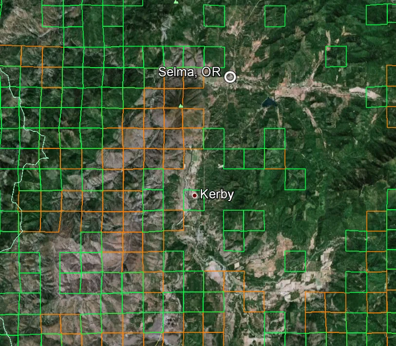
Zoom in to claim lines near Selma
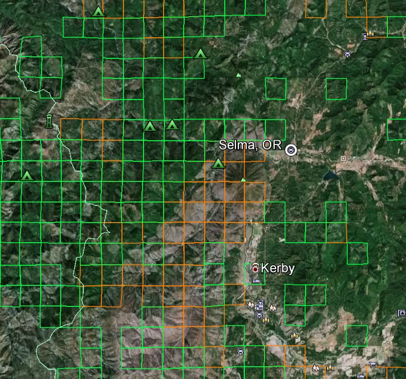
Now zoom in about 20 miles SW of Grant Pass to a little mountain town called Selma Oregon. You can clearly see the active placer (orange) and abandoned placer (green) gold mining claims throughout the area. You are just outside public land in the Siskiyou National Forest. Once inside Siskiyou you can find dozens of non-claimed public gold prospecting locations for you and your family to try your luck at. Our maps will save you at least $200 in gas alone by showing you exactly where to go.
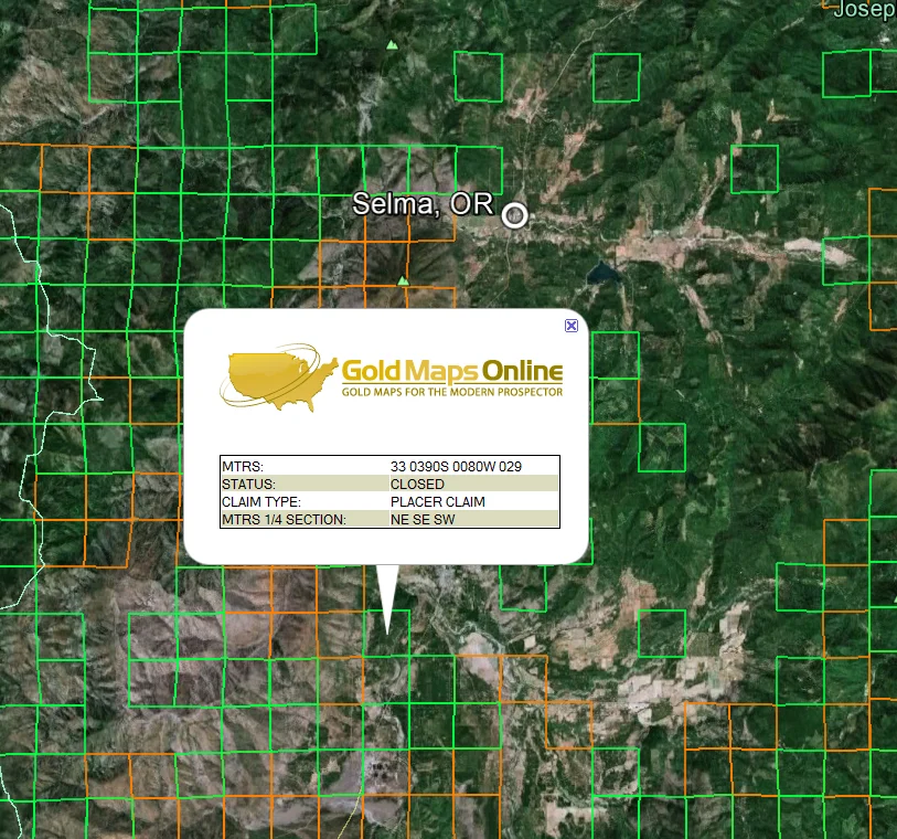
Click a claim to learn more
Zoom in further still and you can click on the active or abandoned placer claims for the MTRS number to determine ownership and other information about the claim(s). This information is for professional prospectors that understand the claiming process. Recreational gold panners should not try to contact claim holders and always stay away from claimed property. Please read more about the MTRS numbers on our Viewing Tips page.
Find camps, trails and roads near Selma
Still looking at the Selma area, turn on the Google Earth™ overlay entitled Parks and Recreation within the More overlay. Now you can see Siskiyou National Forest campgrounds, ranger stations, hiking trails, hotels, gas stations and stores. You can zoom in further still to get a birds-eye view of roads, creeks and other points of interest. Using Google Earth™ satellite imagery, altitude and distance measuring tools will eliminate most surprises like, “I didn’t know that hill was so steep.”
What’s in the Oregon mining claims map: five layers
One 2.0 MB download. Turn each layer on and off in Google Earth, which is free on your computer. How to open your map
Active lode claims
Gold in solid rock, the hard-rock veins
6,489
Active placer claims
Loose gold in sand and gravel
3,615
Abandoned lode claims
Old hard-rock claims nobody pays for anymore
80,647
Abandoned placer claims
Old creek and gravel claims
35,505
Old mines and prospects NEW
Tunnels, shafts, pits, dumps and tailings from USGS topo maps
6,971
Where to pan for gold in Oregon
Turn on the closed placer claims layer. Those boxes mark creeks and gravel where people once staked claims for loose gold. Pick a spot on public land that isn’t inside an active claim, and pan there. New to it? Read how to pan for gold, what abandoned gold claims mean for you, and our state-by-state guide to where to find gold. Not sure what to bring? See our gold prospecting equipment guide.
Looking at gold claims for sale in Oregon?
Find the claim on the map before you buy. Click its section to see how many active claims are there, when the newest one was staked, and how many have closed. The popup also gives the BLM code (MTRS) and a link to BLM’s claim records, so you can check that the claim is still active and who holds it. Our guide to checking a mining claim in BLM’s MLRS shows how.
How Oregon’s mining claims have changed
Oregon had 5,984 active mining claims at the start of 2015. Today it has 10,104, 69% more. Compare all 12 western states, year by year, on the mining claims by state page.
How close you can zoom in
None of the Oregon images above show just how close you can zoom in and see potential gold prospecting sites. You’ll be amazed at how crisp the satellite imagery is and how much exploring and planning you can do from the comfort of your home. And Google Earth™ is free to use in your web browser.
“As a prospector, I must admit that it has already pointed the way to some areas that I intend to prospect.”
Alan Chenworth, author of A Guide to Gold Panning in Utah
Oregon gold mine and history guides
- Historic Oregon Gold Mines Today Old mines
- Basic Oregon Gold Rush History Gold rush history
Prices: save when you add more states
Add more states at checkout. 2 to 4 maps save 25%, 5 to 10 save 35%, and 11 or more save 50%.