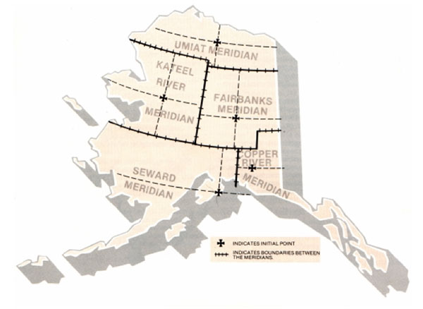
Our 2010 Alaska map shows there are currently 7,776 active gold mining claims located throughout the state. Of those active claims, 5,106 are lode claims and 2,670 are placer claims. Alaska’s active gold mining claims represent about 2% of all active gold claims in America. Alaska is currently the only state we offer that doesn’t include an abandoned claims map. It’s coming soon.

Alaska Gold Map When you first open our Alaska gold map you’ll get a satellite view of the state boundaries with a few little yellow clusters here and there. Those yellow clusters represent concentrations of active gold claims. This view of these yellow clusters gives us an accurate idea of where most of Alaska’s gold is being found. Alaska is the only state we offer that doesn’t have an abandoned claims map. Alaska has its’ own filing system and we are working to correct this.
Alaska Gold Map Now zoom in about 20 miles south of Anchorage to a little town called Hope Alaska on the Kenai Peninsula. You can clearly see the active (yellow) gold mining claim boundaries throughout the area south to Moose Pass. We are not sure what the land status is so do some extra research. If it’s public you may find dozens of non-claimed gold panning sites. The mining claim boundaries shown are accurate to within feet of what you’ll discover at ground level.
Alaska Gold Map Zoom in further still and you can click on any gold claim for ownership and other information about the claim. This information is to help those prospectors wanting to establish their own claims. Recreational gold panners should not try to contact claim holders and always stay away from claimed property. Use the claims to guide you to where the action is but always respect the property rights of others.
Alaska Gold Map Still looking at the Hope/Moose Pass area, turn on the Google Earth™ overlay entitled Places of Interest. Now you can see campgrounds, hiking trails, hotels, gas stations and stores. You can zoom in further still to get a birds-eye view of roads, creeks and other points of interest. Using Google Earth™ satellite imagery, altitude and distance measuring tools will eliminate most surprises like, “I didn’t know that hill was so steep.”

Alaska Gold Prospecting Notes: None of the Alaska images above show just how close you can zoom in and see potential gold panning sites. You’ll be amazed at how crisp the satellite imagery is and how much exploring and planning you can do from the comfort of your home. And Google Earth™ is a free download.

Alaska Active Gold Mining Claims Map
$29.95